![](/images/other/stat-length.png)
![Tocht Te voet Brentino Belluno - Belluno Veronese - Passo del Cerbiolo - Photo](https://media.geolcdn.com/t/1900/400/4e8f8a13-b5f2-473b-88b2-776320ec8c7e.jpeg&format=pjpeg&maxdim=2)
Belluno Veronese - Passo del Cerbiolo
SityTrail - itinéraires balisés pédestres
Tous les sentiers balisés d’Europe GUIDE+
![Lengte](/images/other/stat-length.png)
![Max. hoogte](https://static1.geolcdn.com/siteimages/upload/files/1508320355ic_sort_altitude_max_24dp.png)
![Positief hoogteverschil](https://static1.geolcdn.com/siteimages/upload/files/1508320355ic_sort_den_pos_24dp.png)
![Km-Effort](/images/other/stat-length.png)
![Min. hoogte](https://static1.geolcdn.com/siteimages/upload/files/1508320355ic_sort_altitude_min_24dp.png)
![Negatief hoogteverschil](https://static1.geolcdn.com/siteimages/upload/files/1508320355ic_sort_den_neg_24dp.png)
![Boucle](https://static1.geolcdn.com/siteimages/upload/files/16400158638029165_repeat_loop_refresh_sync_direction_icon.png)
![Te voet](https://static1.geolcdn.com/sitytour/trail-icons/100.png)
4h06
Moeilijkheid : Gemakkelijk
![Scan deze QR-code om de tocht te openen in de SityTrail-applicatie](https://capi.geolives.com/qq0zvz2zws4bq2lad0pu/sitytour/trails/3116870/qr.png?size=200)
Gratisgps-wandelapplicatie
Over ons
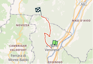
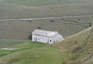
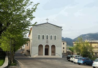
Tocht Te voet van 5,6 km beschikbaar op Veneto, Verona, Brentino Belluno. Deze tocht wordt voorgesteld door SityTrail - itinéraires balisés pédestres.
Beschrijving
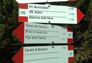
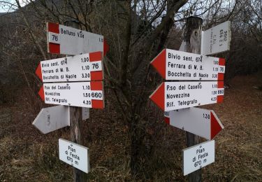
Trail created by Club Alpino Italiano Sezione di San Pietro in Cariano.
relation mantained by Club Alpino Italiano Sezione di San Pietro in Cariano, before making changes contact the CAI structure
Symbol: 678 on white red flag
Website: http://www.caivalpolicella.it
Plaatsbepaling
Opmerkingen
Wandeltochten in de omgeving
![Tocht Te voet Dolcè - Dorsale Media della Lessinia - Photo](https://media.geolcdn.com/t/375/260/afc7e6a9-be91-497d-bf8b-d4a1a7cdc50b.jpeg&format=jpg&maxdim=2)
![Te voet Te voet](https://static1.geolcdn.com/sitytour/trail-icons/100.png)
Te voet
![](/images/other/stat-length.png)
![](https://static1.geolcdn.com/siteimages/upload/files/16400158638029165_repeat_loop_refresh_sync_direction_icon.png)
![Tocht Te voet Dolcè - Peri - Genderli - Photo](https://media.geolcdn.com/t/375/260/777353f4-ff94-483e-9d9b-dfe477a2a7ec.jpeg&format=jpg&maxdim=2)
![Te voet Te voet](https://static1.geolcdn.com/sitytour/trail-icons/100.png)
Te voet
![](/images/other/stat-length.png)
![](https://static1.geolcdn.com/siteimages/upload/files/16400158638029165_repeat_loop_refresh_sync_direction_icon.png)
![Tocht Te voet Sant'Anna d'Alfaedo - Dorsale Alta della Lessinia - 4° tratto - Sentiero di Rocca Pia - Photo](https://media.geolcdn.com/t/375/260/a8c0a9df-6f17-4400-a005-59d56ad0f479.jpeg&format=jpg&maxdim=2)
![Te voet Te voet](https://static1.geolcdn.com/sitytour/trail-icons/100.png)
Te voet
![](/images/other/stat-length.png)
![](https://static1.geolcdn.com/siteimages/upload/files/16400158638029165_repeat_loop_refresh_sync_direction_icon.png)
![Tocht Te voet Dolcè - Dorsale Alta della Lessinia - Photo](https://media.geolcdn.com/t/375/260/83a31790-dc1e-4af9-b4ba-530f507478c5.jpeg&format=jpg&maxdim=2)
![Te voet Te voet](https://static1.geolcdn.com/sitytour/trail-icons/100.png)
Te voet
![](/images/other/stat-length.png)
![](https://static1.geolcdn.com/siteimages/upload/files/16400158638029165_repeat_loop_refresh_sync_direction_icon.png)
![Tocht Te voet Sant'Anna d'Alfaedo - Dorsale Alta della Lessinia sezione Passo Fittanze - Tommasi - Photo](https://media.geolcdn.com/t/375/260/b1092593-b5b7-4abe-b57e-c7a3af9fcea8.jpeg&format=jpg&maxdim=2)
![Te voet Te voet](https://static1.geolcdn.com/sitytour/trail-icons/100.png)
Te voet
![](/images/other/stat-length.png)
![](https://static1.geolcdn.com/siteimages/upload/files/16400158638029165_repeat_loop_refresh_sync_direction_icon.png)
![Tocht Te voet Avio - Sentiero Bovi - Photo](https://media.geolcdn.com/t/375/260/4702fb67-6073-457f-bd90-e77faeb3b6e8.jpeg&format=jpg&maxdim=2)
![Te voet Te voet](https://static1.geolcdn.com/sitytour/trail-icons/100.png)
Te voet
![](/images/other/stat-length.png)
![](https://static1.geolcdn.com/siteimages/upload/files/16400158638029165_repeat_loop_refresh_sync_direction_icon.png)
![Tocht Te voet Ferrara di Monte Baldo - Sentiero Agostino Goiran - Photo](https://media.geolcdn.com/t/375/260/22e59220-543c-460c-85bc-686efa3a6b75.jpeg&format=jpg&maxdim=2)
![Te voet Te voet](https://static1.geolcdn.com/sitytour/trail-icons/100.png)
Te voet
![](/images/other/stat-length.png)
![](https://static1.geolcdn.com/siteimages/upload/files/16400158638029165_repeat_loop_refresh_sync_direction_icon.png)
![Tocht Te voet Ferrara di Monte Baldo - Belluno Veronese - Ferrara di Monte Baldo - Photo](https://media.geolcdn.com/t/375/260/df35d1f2-ff15-446a-a202-4932293f3539.jpeg&format=jpg&maxdim=2)
![Te voet Te voet](https://static1.geolcdn.com/sitytour/trail-icons/100.png)
Te voet
![](/images/other/stat-length.png)
![](https://static1.geolcdn.com/siteimages/upload/files/16400158638029165_repeat_loop_refresh_sync_direction_icon.png)
![Tocht Te voet Sant'Anna d'Alfaedo - Tommasi - Corno d'Aquilio - Photo](https://media.geolcdn.com/t/375/260/33839697-309b-4a41-a6be-57c145ca1bcd.jpeg&format=jpg&maxdim=2)
![Te voet Te voet](https://static1.geolcdn.com/sitytour/trail-icons/100.png)
Te voet
![](/images/other/stat-length.png)
![](https://static1.geolcdn.com/siteimages/upload/files/16400158638029165_repeat_loop_refresh_sync_direction_icon.png)